THE HISTORY OF OUR VILLAGE OF STANSTEAD ABBOTTS
Although the earliest mention of our village is to be found in the Domesday Book
(1086), it is certain that a settlement existed around the present Stansteadbury
many centuries earlier. It’s very prominent position overlooking both the Lea and
Stort Valleys makes it an obvious place for a village. In those days, of course,
the rivers were much wider, occupying almost the whole of the valleys, with Terbets
Hill (where Stansteadbury now stands) rising above the water .Shells and remains
of pottery etc.found along the ridge of the hill show how wide the waters were in
those far-
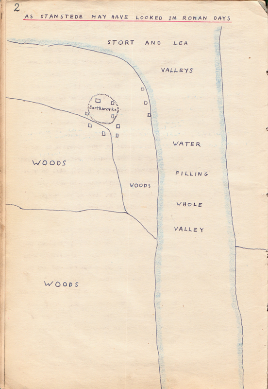
No Roman road of any great importance exists nearer than St Albans, though there is a wide Roman trackway from Hertford Heath to Broxbourne woods, but even in those days there would be a track winding its way from the settlement at Terbets Hill to the river crossing near the present Pied Bull corner, following much the same path that the road follows today. The map on the next page shows what the settlement may have been like in Roman and Saxon times.
Later on, when King Alfred was striving to withstand the attacks of the Danes, the village must have had stirring times, for the Danes sailed their vessels up the Lea as far as Ware and remained there for months living on plunder from the surrounding countryside.
Alfred’s scheme, whereby he caused several channels to be dug at Waltham thus lowering the river level here and stranding the Danish vessels, led to his victory over the Danes in this district and it was fortunate for our village that the Danes fought their way to the west and so missed it. Even so, the people must have been glad to see the enemy go, for their treatment of villages in their path is well known for its brutality. It is of interest that when Thele Bridge was rebuilt in 1615 planks and large nails, parts of sunken Danish vessels, were found in the riverbed. Following this, peace presumably prevailed, except for the inter village quarrels which were so frequent then.
Fighting appears to have affected us again after the Battle of Hastings for the Domesday records the value of the manor ie the buildings, fields , animals , etcto have been £17 in the time of Edward the Confessor, £10 when the Normans first settled in and £20 at the time of the survey. Areas which suffered through warfare against the Normans show this drop and subsequent rise in value.
When the Domesday survey was carried out for William the Conqueror Stanstede( as
it was spelt then) had grown to quite an important place, far bigger than either
Ware or Hoddesdon for instance, and it included Hunsdon and Rye in its bounds. The
following is the reference to Stanstede in the Domesday Book:-
Ranulphus holds in Stanstede 17 hides and half a virgate. The arable land is 16
carucates. In the demesne are 13 hides, and there are 2 carucates there, and a third
may be made. Four villeins, with a priest and and bailiff of the vill, and 4 foreigners,
have 8 carucates there, and 5 may yet be made. There are 6 cottagers and 2 bondmen,
and a mill of 10 shillings. Meadow, 16 carucates; pasture for cattle of the vill;
Pannage for 100 hogs. There are also 7 burgesses who pay, with other customs for
meadow and wood, 23/-
“Alwine de Godtone held of this manor 11 hides and half a virgate; and all of these Ralph Talgebosh gave 10 to Ranulphus with his niece in marriage , and the 11th hide he laid to Honesdone. Four socmen held other 7 hides . Four of these vassals of Anschitil had 4 hides; but 10 other vassals of Alwine had 3 hides and they paid to the King’s sheriff for custom 12 pence a year . In Stanstede a certain socman holds of Geoffrey half a hide. The arable land is half a carucate, and there is one cottager. The meadow is half a carucate. In Stanstede, Godmund holds of the King 3 virgates. There is land to 6 oxen, and they are there with four bordars.Meadow, one carucate.Pannage for 8 hogs.
Note :-
COTTAGERS or COTARS could be called upon by the Lord for any work he needed done at any time.
Villeins were permanent fixtures of the farms and went with the farms if they were sold.
From this the following may be surmised :-
1. a MILL and a CHURCH existed, almost certainly on the same sites as today.
2. The Manor was a valuable one for a bailiff and seven burgesses correspond roughly to a Mayor and corporation today. It should also be noted that the name STANSTEDE meant “a stony settlement “ that whether the stony refers to the material with which the dwellings were constructed or to the gravelly soil is not certain though the latter is probable .
From Ranulph, the Manor passed into the hands of Roger de Wancy and in about 1100 he gave the Advowson (the control of the church and the income from the church lands ) to the Prior and Convent of Merton in Surrey.
About 1150 we first hear of the bridge of Thele (Thele was the original name for St Margaret’s) so that our river crossing at the head of the High Street has existed for at least 800 years. This bridge was the first hereabouts, for in 1200 AD a court held in Hertford ordered local landowners to build more bridges at various points between Ware and Wormley. The fact that ours was the first bridge no doubt accounts for the importance of Stanstede then, for travellers are the ones who bring trade and prosperity to any place and all would have to pass here on their way across the river.
It was at this time that the Manor passed into the hands of the Abbey of Waltham, Michael de Wancy being in need of money to repay a debt to a Jew named Brune. He gave half of the Manor to the Abbey in return for an annual rent of £12, and the other half and the bridge of Thele to the King (Henry II) who gave this half also to the Abbey. As a result of this gift to the Abbey the name Abbott or Abbotts was added to Stanstede.
In 1293 we read that an inquiry was instituted into the character of John Vicar of Stanstede, and it could not have been many years later that work was begun on the present St James’ church, only the Eastern part (today’s chancel ) being the first part to be built , this would be about 1350 – 1400.
Though Easneye had been mentioned earlier it was not until 1330 that the Canons of Waltham obtained permission to enclose the woods there as a park , and it was to a further 540 years before a house was built there to supersede the manor of Stansteadbury.
In 1342 Edward III ordered an inquiry into the privileges and customs of Hertford from which it emerges that the tolls payable at Thele Bridge were taken by Hertford. The name Thele would appear to be a contraction of Thelonium, Saxon for toll and as Stanstede le Thele appears in Domesday Book tolls must have been levied here from very early days.
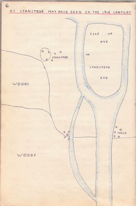
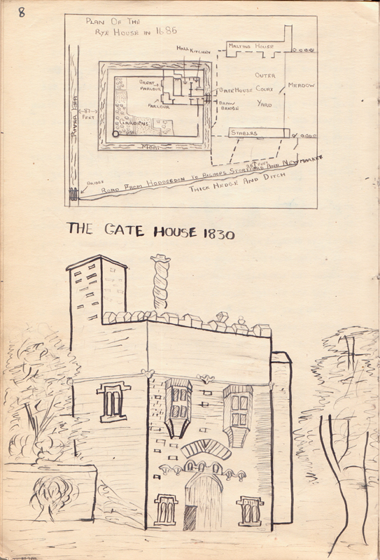
During the years 1420 to 1432 the river Lea was made navigable and this would naturally help to drain the valley , so it is not surprising that in 1440 Sir Andrew Ogard obtains permission to enclose a park at Rye and to build a castle there. The map on the opposite page shows how by these times the water level has changed and we find the Isle of Rye mentioned. The mill having been built much earlier stands where the river had reached, and the mill stream would have been one of several crossing the village street. The castle built at the Rye was the one which gave the name House to Rye House and is mentioned in connection with the Rye House Plot (see later). There followsshows a plan of the castle as it was in 1685 and a picture of the gatehouse in 1800 , all that was left by that date .
With the coming of the Tudors to the throne of England ,Stanstede Abbotts entered its most active historical period. The fact that Henry VIII kept a palace as Hunsdon and one at Hatfield must have meant frequent journeys through this village and the villagers may well have seen too much of their despotic King who would need to be provided for very liberally from the people. In 1531 the King obtained the Manor of Stanstede Abbotts from the Canons of Waltham in exchange for Blackmore in Essex, and united it and the manor of Roydon with Hunsdon, creating the Honor of Hunsdon. Thus for a while fortunes were reversed ,Stanstede, once including Hunsdon in its manor, being now a part of Hunsdon. Henry VIII lived for many years at Hunsdon and his children, Edward, Mary and Elizabeth were brought up there in the house which he had bought from the Boleyns and improved for his own use . The place was chosen for “the breeding and education of his children in respect of the benefit of the air.” Plagues being frequent , this decision seems to be a wise one . The Royal journeys to and from London would pass along the Toll road.
These were days of intrigue and plots and Henry’s many marriages (one to Anne Boleyn of Hunsdon) lead to bitter quarrels as to the rightful heir to the Throne. One result was that on the death of Edward VI, Mary received a message at Hunsdon that he wished to see her. Hastening along the Toll road , she reached Hoddesdon before meeting another messenger who told her of the King’s death and that the previous message was a trick.
Returning to the story of the manor of Stanstede we shall not be surprised that at the Dissolution of the Monasteries in 1542 the Crown seized the manor from the Abbotts of Waltham, letting it subsequently to Philip Paris for the annual rent of 4/4. By this time the Honour of Hunsdon appears to have been split into its original parts and there is no further connection with Hunsdon in our story. From Philip Paris the manor passed in 1559 to Edward Baesh, the first of the family to whom our village owes so much. He it was who added the north chapel to St James’s church and also the south porch, the floor of which is paved with the lids of stone coffins dug up when the foundations of the north chapel were being dug. The tower had been built about 100 years before this, while the church had been enlarged with the result that it is not straight for its entire length. At some time its arrangement was altered for there still remain signs of a Rood screen at the back of a pew opposite the pulpit. These alterations may have been made in the 17th century when the box pews were installed. The Edward Baesh who added to the church was General Surveyor of victuals for the Royal Navy in the reigns of Henry VIII, Edward VI, Mary and Elizabeth, evidently amassing a fortune part of which was to be lavished on the village by his grandson, another Edward Baesh.